Weather station & monitoring software
Calibration & maintenance


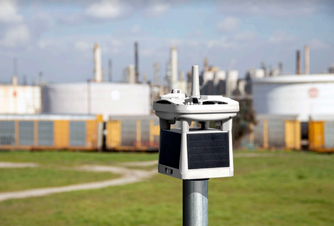
Industrial Weather Stations for Safety, Efficiency, and Compliance
Many industries rely on accurate, real-time weather data to keep operations safe, efficient, and compliant. What starts as a requirement for environmental licenses often becomes an essential tool for smarter site management.
Enhance Day-to-Day Operations
An automatic weather station gives you the power to make informed decisions every day:
-
Protect Your Team: Monitor heat stress to safeguard employees and contractors.
-
Plan Work Zones: Adjust schedules and activities based on rainfall or ambient conditions.
-
Optimize Processes: React to wind speed, temperature, and other environmental factors to maintain productivity.
Long-Term Planning & Strategic Insights
Weather data isn’t just for today—it’s an investment in smarter operations:
-
Rainfall Analysis: Understand when rain impacts operations and plan accordingly.
-
Dust & Airflow Planning: Use prevailing wind data to minimize dust from mills or plants.
-
Process Control Integration: Connect weather data to SCADA or process systems to automate decisions and improve efficiency.
Complete, Reliable Weather Solutions
Environ data provides fully integrated weather station systems, including sensors, data loggers, masts, and installation. With over 10 years of operational life, our rugged, reliable stations deliver accurate data for industrial sites across Australia.
We supply, install, and maintain stations for mining, road construction projects and other industrial applications, ensuring compliance and reducing long-term maintenance.
Reporting Made Easy
Our Weathercasting LIVE and Self-Hosted Software make reporting simple and flexible:
-
Customizable reports for wind roses, rainfall summaries, thermal work limits, and more
-
Export data directly to Excel or Word for easy documentation
-
Quick access to historical and real-time weather insights for operational planning
Flexible Integration Options
Environ data stations are designed to fit your system:
-
Direct serial or MODBUS connection for PLCs, RTUs, or SCADA integration
-
Pulse and 4–20mA output options for sensor-only installations
-
Robust sensors built for harsh industrial environments
Why Choose Eeko Solutions?
Our weather stations do more than meet compliance requirements—they improve safety, productivity, and operational efficiency. With industry-leading accuracy, durability, and support, Environ data is trusted by industrial clients across Australia to provide actionable weather insights every day.
Focused on site safety monitoring, NSW R272 weather station

Temperature
Barometric Pressure
Humidity
Precipitation
Cloud Ceiling
Wind Speed
Wind Direction
Angular Tilt
Lightning detection sensor

Smarter Weather Station Intelligence for Mining, Ports, Airports and more
Eeko Solutions delivers advanced weather station technology with AI-powered hardware & software
✅ Real-time lightning detection & Alerts
✅ Weather data with parameters & Alerts
✅ Custom thresholds & instant reporting
✅ Remote access & web-based monitoring
✅ Built to Bureau Standards
✅ Full support + Low Maintenance
📡 Designed for speed, accuracy & safety.
📞 Let us talk safety and improving productivity today.


Tripod Lattice Tower


Tripod Lattice Tower Specs
Portable Tripod Lattice Tower-8 meters
Serviceable Design
Light weight winched-up design (Aluminium Construction)
Heavy Duty galvanise tripod outrigger base
2 -3 hour setup time
8-meter total height (6.2m Lattice)
220mm wide body (180mm faced)
3100mm section lengths
Quick, simple winch raising (Winch Included)
Low maintenance Aluminium construction
Max Windspeed 150km
The Tripod Lattice Tower is used for weather stations, CMCE Lightning Suppressor, Comms and a range of different products.
Easily drop down system using the winch for annual maintenance of or when work has to be done.
No need to work from heights.
Portable Tripod Lattice Tower-11 meters
Serviceable Design
Light weight winched-up design (Aluminium Construction
Heavy Duty galvanised tripod outrigger base
3-4 hour setup time
11-meter total height (9.3m Lattice)
340mm wide body
3100mm section lengths
Quick, simple winch raising (Winch Included)
Low maintenance Aluminium construction
Max Windspeed 150km
Portable Tripod Lattice Tower-14 meters
Serviceable Design
Light weight winched-up design (Aluminium Construction)
Heavy Duty galvanise tripod outrigger base
3-4 hour setup time
14-meter total height (9.3m Lattice)
340mm wide body
3100mm section lengths
Quick, simple winch raising (Winch Included)
Low maintenance Aluminium construction
Max Windspeed 150km

Winch-Raised Galvanised Hinged Mast


Serviceable Designed
3m to 8m mast heights
100x100 box
Braked 1.2 ton winch
Low maintenance galvanised construction
Request a quote
Do what’s Right
Seek better Ways
Make a Difference
Focused on Safety
Precision Meets Protection